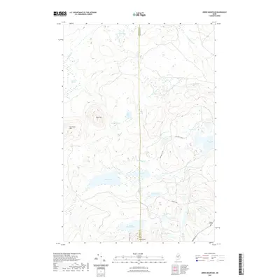
2021 Map of Green Mountain
USGS Topo · Published 2021About this map
Marley Bradford Cem serves as a small historical anchor in this north woods landscape, situated along the Masardis Rd near the eastern boundary. The terrain is defined by low-lying wetlands and significant peaks, including Green Mtn and Pickett Mtn. Water dominates the hydrology of the area, where the W Br Mattawamkeag River flows near the expansive Rockabema Lake. The map details a network of unpaved access routes like Mud Lake Tote Rd and McManus Tote Rd, which cut through the timbered reaches and meadows.
Find a feature on this map
35 named features on this map. Tap any name to fly to it.
Don’t see what you’re looking for? This feature index may not catch every label — zoom into the map to look around manually.
Map Details
Editions of this 2021 Green Mountain Map
This is the sole edition of this map. No revisions or reprints were ever made.
Other maps of this area

1940 · Island Falls
USGS Topo · 1:62,500

1940 · Oxbow
USGS Topo · 1:62,500

1942 · Island Falls
USGS Topo · 1:62,500

1942 · Oxbow
USGS Topo · 1:62,500

1954 · Shin Pond
USGS Topo · 1:62,500

1954 · Grand Lake Seboeis
USGS Topo · 1:62,500

1954 · Presque Isle
USGS Topo · 1:250,000

1958 · Presque Isle
USGS Topo · 1:250,000

1960 · Presque Isle
USGS Topo · 1:250,000
1965 · Oxbow
USGS Topo · 1:62,500