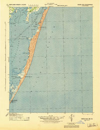
1944 Map of Green Run
USGS Topo · Published 1944About this map
Chincoteague Bay and the coastal barrier islands of the Eastern Shore are documented here in this mid-century Army Map Service study. The geography is defined by a complex network of bays, including Sinepuxent Bay and Newport Bay, separated from the Atlantic Ocean by narrow strips of land such as Great Egging Beach and Little Egging Beach. This maritime landscape was guarded by a string of Coast Guard Stations, with facilities at North Beach, Green Run Inlet, and Pope Island providing critical safety infrastructure along this stretch of the Atlantic coast. Inland, the map details the marshy reaches of Newport Neck and numerous islands like Tingle Island and Cropper Island. The lack of inland development at this time highlights the area's isolation and its reliance on the water, with named landmarks like Winter Quarter and Lumber Marsh hinting at early land use patterns.
Find a feature on this map
37 named features on this map. Tap any name to fly to it.
Don’t see what you’re looking for? This feature index may not catch every label — zoom into the map to look around manually.
Map Details
Editions of this 1944 Green Run Map
This is the sole edition of this map. No revisions or reprints were ever made.
Other maps of this area

1901 · Snow Hill
USGS Topo · 1:62,500

1901 · Green Run
USGS Topo · 1:62,500

1901 · Ocean City
USGS Topo · 1:62,500

1902 · Pittsville
USGS Topo · 1:62,500

1938 · Green Run
USGS Topo · 1:62,500

1942 · Ocean City
USGS Topo · 1:62,500

1942 · Chincoteague East
USGS Topo · 1:24,000

1942 · Ninepin
USGS Topo · 1:24,000

1942 · Ocean City
USGS Topo · 1:24,000

1942 · Tingles Island
USGS Topo · 1:24,000