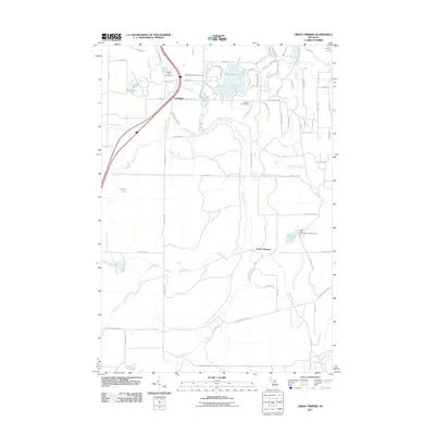
2011 Map of Green Timbers
USGS Topo · Published 2011About this map
The Sturgeon River flows centrally through this landscape, defining the character of a region heavily utilized for outdoor recreation and conservation. In the northern reaches, the small settlement of Trowbridge sits near the riverbanks, complemented by the Sturgeon River Campground and the Wildwood Lake Golf Course. The map reveals a high concentration of water bodies including Wildwood Lake, Lance Lake, and the more secluded Storey Lake. To the south, the namesake Green Timbers area serves as a focal point for the natural environment, where Club Stream joins the main river system. The presence of the Pickerel Lake State Forest Campground near Pickerel Lake highlights the importance of state-managed lands for local access. A network of primitive roads and trails like Cornwell Grade Rd and Honeylocust Trl suggest a history of forestry or conservation access in this part of Michigan.
Find a feature on this map
86 named features on this map. Tap any name to fly to it.
Don’t see what you’re looking for? This feature index may not catch every label — zoom into the map to look around manually.
Map Details
Editions of this 2011 Green Timbers Map
This is the sole edition of this map. No revisions or reprints were ever made.
Other maps of this area

1954 · Gaylord
USGS Topo · 1:62,500

1954 · Hetherton
USGS Topo · 1:62,500

1955 · Cheboygan
USGS Topo · 1:250,000

1957 · Tower
USGS Topo · 1:62,500

1957 · Wolverine
USGS Topo · 1:62,500

1958 · Cheboygan
USGS Topo · 1:250,000
1975 · Gaylord SW
USGS Topo · 1:24,000

1982 · Petoskey
USGS Topo · 1:100,000
1986 · Saunders Creek
USGS Topo · 1:24,000
1986 · Green Timbers
USGS Topo · 1:24,000