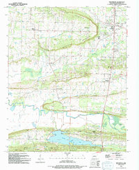
1994 Map of Greenbrier
USGS Topo · Published 1994About this map
Greenbrier serves as a focal point in this 1990s Arkansas landscape, situated where the terrain transitions from the ridges of Horseshoe Mountain toward the valley floors. The map details a community defined by its rural institutions and water resources, featuring several local congregations such as Bethlehem Ch and Mountain Grove Ch. To the south, the extensive reach of Beaver Fork Lake dominates the topography, complete with Beaver Fork Park, a Boat Ramp, and Picnic Point, indicating the area's development for recreation alongside established settlements like Wooster and Pleasant Valley. Landforms such as Springfellow Hill and Kaney Ridge dictate the winding paths of Greenbrier Creek and the East Fork Cadron Creek. Local industry is represented by Shale Pits found near Springhill, while the presence of Pearson Cem and Estep Cem provides valuable data for those tracing family history in Faulkner County.
Find a feature on this map
44 named features on this map. Tap any name to fly to it.
Don’t see what you’re looking for? This feature index may not catch every label — zoom into the map to look around manually.
Map Details
Editions of this 1994 Greenbrier Map
This is the sole edition of this map. No revisions or reprints were ever made.
Other maps of this area

1892 · Morrillton
USGS Topo · 1:125,000

1894 · Morrillton
USGS Topo · 1:125,000

1956 · Russellville
USGS Topo · 1:250,000

1961 · Menifee
USGS Topo · 1:24,000

1961 · Gleason
USGS Topo · 1:24,000

1961 · Conway
USGS Topo · 1:24,000

1961 · Conway
USGS Topo · 1:62,500

1961 · Bee Branch
USGS Topo · 1:62,500

1961 · Greenbrier
USGS Topo · 1:24,000

1961 · Damascus
USGS Topo · 1:24,000