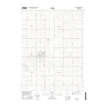
2015 Map of Greenfield
USGS Topo · Published 2015About this map
The Iowa town of Greenfield serves as the central hub of this Adair County landscape, where the grid of city streets like NW Grant St and E Iowa St meets the sprawling agricultural sections of the Midwest. The area's water management and recreation are visible in Greenfield Lake and Nodaway Lake to the west, while the northern reaches are drained by the Thompson River and Bruce Br. The map documents the local aviation infrastructure at the Greenfield Municipal Airport and the placement of the Adair County Cem and Greenfield Cem, providing essential data for genealogists. Multiple creek systems, including Marvel Cr and Ninemile Cr, carve through the terrain, illustrating the natural drainage patterns that have historically influenced the placement of rural roads and farmsteads.
Find a feature on this map
55 named features on this map. Tap any name to fly to it.
Don’t see what you’re looking for? This feature index may not catch every label — zoom into the map to look around manually.
Map Details
Editions of this 2015 Greenfield Map
This is the sole edition of this map. No revisions or reprints were ever made.
Other maps of this area

1954 · Greenfield
USGS Topo · 1:62,500

1954 · Omaha
USGS Topo · 1:250,000

1957 · Omaha
USGS Topo · 1:250,000

1958 · Omaha
USGS Topo · 1:250,000

1971 · Fontanelle
USGS Topo · 1:24,000

1971 · Canby
USGS Topo · 1:24,000

1980 · Nevinville
USGS Topo · 1:24,000

1981 · Zion
USGS Topo · 1:24,000
1981 · Orient
USGS Topo · 1:24,000
1983 · Rosserdale
USGS Topo · 1:24,000