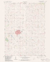
1983 Map of Greenfield
USGS Topo · Published 1984About this map
Greenfield serves as the focal point of this Adair County landscape, situated at a key intersection of prairie transit during the early 1980s. The town's layout reveals a structured civic core, featuring the High Sch, Jr High Sch, and the County Memorial Hospital. The surrounding terrain is defined by the drainage of the Middle Nodaway River and Thompson River, while the Burlington Northern railroad cuts through the southern portion of the township, marking the enduring importance of rail transport for this agricultural hub.
Find a feature on this map
30 named features on this map. Tap any name to fly to it.
Don’t see what you’re looking for? This feature index may not catch every label — zoom into the map to look around manually.
Map Details
Editions of this 1983 Greenfield Map
This is the sole edition of this map. No revisions or reprints were ever made.
Other maps of this area

1954 · Greenfield
USGS Topo · 1:62,500

1954 · Omaha
USGS Topo · 1:250,000

1957 · Omaha
USGS Topo · 1:250,000

1958 · Omaha
USGS Topo · 1:250,000

1971 · Fontanelle
USGS Topo · 1:24,000

1971 · Canby
USGS Topo · 1:24,000

1980 · Nevinville
USGS Topo · 1:24,000

1981 · Zion
USGS Topo · 1:24,000
1981 · Orient
USGS Topo · 1:24,000
1983 · Rosserdale
USGS Topo · 1:24,000