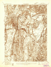
1936 Map of Greenfield
USGS Topo · Published 1936About this map
The Connecticut River serves as the central artery for this mid-1930s landscape, winding through a complex network of rail lines and industrial settlements. The major transportation hubs of Greenfield and Montague City are meticulously detailed, showing the convergence of the Boston And Maine Railroad and the Central Vermont Railway. These rail corridors were vital to the local economy, connecting the agricultural lands around Old Deerfield to the industrial centers of the Pioneer Valley.
Find a feature on this map
70 named features on this map. Tap any name to fly to it.
Don’t see what you’re looking for? This feature index may not catch every label — zoom into the map to look around manually.
Map Details
Editions of this 1936 Greenfield Map
This is the sole edition of this map. No revisions or reprints were ever made.
Other maps of this area

1885 · Northampton
USGS Topo · 1:62,500

1886 · Northampton
USGS Topo · 1:62,500

1887 · Warwick
USGS Topo · 1:62,500

1887 · Belchertown
USGS Topo · 1:62,500

1889 · Warwick
USGS Topo · 1:62,500

1890 · Belchertown
USGS Topo · 1:62,500

1890 · Greenfield
USGS Topo · 1:62,500

1891 · Northampton
USGS Topo · 1:62,500

1893 · Northampton
USGS Topo · 1:62,500

1893 · Belchertown
USGS Topo · 1:62,500