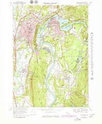
1968 Map of Greenfield
USGS Topo · Published 1979About this map
Greenfield and the neighboring industrial hubs of Turners Falls and Montague City occupy this bend of the Connecticut River in the late 1960s. The landscape is defined by its educational and civic institutions, ranging from the campus of Deerfield Academy and Stoneleigh-Burnham School to the County Jail and Franklin County Hospital. The rugged Pocumtuck Range and Rocky Mountain provide a sharp vertical contrast to the fertile South Meadows, where the Green River and Deerfield river systems converge.
Find a feature on this map
100 named features on this map. Tap any name to fly to it.
Don’t see what you’re looking for? This feature index may not catch every label — zoom into the map to look around manually.
Map Details
Editions of this 1968 Greenfield Map
This is the sole edition of this map. No revisions or reprints were ever made.
Other maps of this area

1885 · Northampton
USGS Topo · 1:62,500

1886 · Northampton
USGS Topo · 1:62,500

1887 · Warwick
USGS Topo · 1:62,500

1887 · Belchertown
USGS Topo · 1:62,500

1889 · Warwick
USGS Topo · 1:62,500

1890 · Belchertown
USGS Topo · 1:62,500

1890 · Greenfield
USGS Topo · 1:62,500
1891 · Northampton
USGS Topo · 1:62,500
1893 · Northampton
USGS Topo · 1:62,500
1893 · Belchertown
USGS Topo · 1:62,500