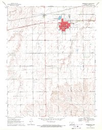
1969 Map of Greensburg
USGS Topo · Published 1971About this map
Greensburg stands as the central hub of this Kansas landscape, serving as the seat of Kiowa County during the late 1960s. The town's grid is dense with civic importance, featuring a Courthouse, a Post Office, and a High School that anchored the community. To the north, the Chicago Rock Island and Pacific railroad parallels Highway 54, illustrating the critical transportation corridor that historically linked these prairie towns to larger markets.
Find a feature on this map
27 named features on this map. Tap any name to fly to it.
Don’t see what you’re looking for? This feature index may not catch every label — zoom into the map to look around manually.
Map Details
Editions of this 1969 Greensburg Map
This is the sole edition of this map. No revisions or reprints were ever made.
Other maps of this area

1889 · Kinsley
USGS Topo · 1:125,000

1892 · Kinsley
USGS Topo · 1:125,000

1892 · Coldwater
USGS Topo · 1:125,000

1894 · Kinsley
USGS Topo · 1:125,000

1955 · Pratt
USGS Topo · 1:250,000

1959 · Pratt
USGS Topo · 1:250,000

1968 · Haviland NW
USGS Topo · 1:24,000

1968 · Brenham
USGS Topo · 1:24,000

1969 · Greensburg NW
USGS Topo · 1:24,000
1969 · Mullinville
USGS Topo · 1:24,000