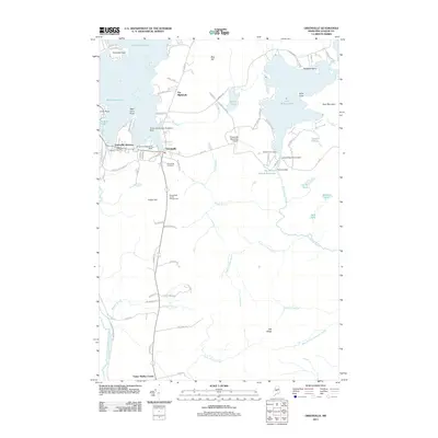
2011 Map of Greenville
USGS Topo · Published 2011About this map
Greenville and Greenville Junction serve as the southern gateway to the massive wilderness of Moosehead Lake in this 2011 survey. The region's deep connection to aviation and forestry is evident through several specialized landmarks, including the Greenville Forestry Seaplane Base, the Greenville Seaplane Base, and the Greenville Municipal Airport. These facilities reflect the area's role as a logistical hub for the North Maine Woods, where aircraft are essential for both commerce and recreation.
Find a feature on this map
84 named features on this map. Tap any name to fly to it.
Don’t see what you’re looking for? This feature index may not catch every label — zoom into the map to look around manually.
Map Details
Editions of this 2011 Greenville Map
This is the sole edition of this map. No revisions or reprints were ever made.
Other maps of this area

1920 · Moosehead Lake
USGS Topo · 1:62,500

1922 · Moosehead Lake
USGS Topo · 1:62,500

1930 · Moosehead Lake
USGS Topo · 1:62,500

1944 · Moosehead Lake
USGS Topo · 1:62,500

1950 · Sebec Lake
USGS Topo · 1:62,500

1951 · Greenville
USGS Topo · 1:62,500

1952 · First Roach Pond
USGS Topo · 1:62,500

1954 · Millinocket
USGS Topo · 1:250,000

1957 · Moosehead Lake
USGS Topo · 1:62,500

1958 · Millinocket
USGS Topo · 1:250,000
Featured Places
- Greenville, ME
- Shirley, ME
- Greenville Junction, Greenville
- Cove Point Township, ME
- Moosehead Junction Township, ME