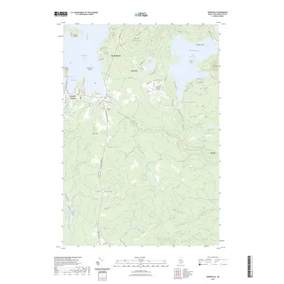
2023 Map of Greenville
USGS Topo · Published 2023About this map
Greenville Junction and the town of Greenville serve as the southern gateway to the massive waters of Moosehead Lake, as documented in this modern survey. The landscape is defined by the transition from the lakeside settlements to the rising elevations of Scammon Ridge and Blair Hill. Local navigation and land use are centered around water bodies, from the industrial utility of the Big Wilson Stream Reservoir to the natural expanse of Lower Wilson Pond and the wetlands of East Shirley Bog. Residents and visitors travel along Lily Bay RD and Moosehead Lake RD, while the Greenville Municipal Airport facilitates air access to this remote region. For genealogists and local historians, the Greenville Cem and the residential clusters at The Highlands provide specific points of reference within the township's established geography.
Find a feature on this map
83 named features on this map. Tap any name to fly to it.
Don’t see what you’re looking for? This feature index may not catch every label — zoom into the map to look around manually.
Map Details
Editions of this 2023 Greenville Map
This is the sole edition of this map. No revisions or reprints were ever made.
Other maps of this area

1920 · Moosehead Lake
USGS Topo · 1:62,500

1922 · Moosehead Lake
USGS Topo · 1:62,500

1930 · Moosehead Lake
USGS Topo · 1:62,500

1944 · Moosehead Lake
USGS Topo · 1:62,500

1950 · Sebec Lake
USGS Topo · 1:62,500

1951 · Greenville
USGS Topo · 1:62,500

1952 · First Roach Pond
USGS Topo · 1:62,500

1954 · Millinocket
USGS Topo · 1:250,000

1957 · Moosehead Lake
USGS Topo · 1:62,500

1958 · Millinocket
USGS Topo · 1:250,000
Featured Places
- Greenville, ME
- Shirley, ME
- Greenville Junction, Greenville
- Cove Point Township, ME
- Moosehead Junction Township, ME