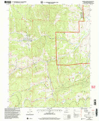
2001 Map of Grouse Creek
USGS Topo · Published 2005About this map
Rio Grande National Forest dominates this Saguache County landscape, where the historical Wagon Wheel Cut-Off Tr winds through the terrain. The hydrological network is defined by Saguache Creek and its many tributaries, including Fourmile Creek, Moon Creek, and Duckfoot Creek. Notable elevation markers like Hat Mountain and depressions such as Andys Hole punctuate the high-altitude geography. The map traces several specialized paths, including the Fourmile Trail and Trough Trail, which served as vital access routes through areas like California Gulch and Lost Park. These trails and named gulches reflect a legacy of land use and transit prior to modern development, while the presence of Hat Springs indicates the importance of natural water sources in this environment.
Find a feature on this map
22 named features on this map. Tap any name to fly to it.
Don’t see what you’re looking for? This feature index may not catch every label — zoom into the map to look around manually.
Map Details
Editions of this 2001 Grouse Creek Map
This is the sole edition of this map. No revisions or reprints were ever made.
Other maps of this area

1914 · Creede
USGS Topo · 1:125,000

1915 · Del Norte
USGS Topo · 1:125,000

1916 · Creede
USGS Topo · 1:125,000

1917 · Del Norte
USGS Topo · 1:125,000

1945 · Durango
USGS Topo · 1:250,000

1953 · Durango
USGS Topo · 1:250,000

1954 · Durango
USGS Topo · 1:250,000

1956 · Montrose
USGS Topo · 1:250,000

1959 · Montrose
USGS Topo · 1:250,000

1960 · Montrose
USGS Topo · 1:250,000