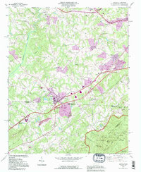
1993 Map of Grover
USGS Topo · Published 1996About this map
Grover sits at the literal center of this map, straddling the state line between Cleveland County, North Carolina, and Cherokee County, South Carolina. The landscape is defined by the transitioning topography as the piedmont rises toward Whitaker Mountain and the Kings Mountain Ridge in the south. This area serves as a significant historical corridor, marked by the expansive Kings Mountain National Military Park and its sister Kings Mountain State Park. Local life is anchored by a dense network of country churches and small family burying grounds, including Bethlehem Temple, St Peters Ch, and Clingman Memorial Cem. The industrial footprint of the late 20th century is evident through several large Quarry sites and an Industrial Waste Pond, contrasting with the numerous creeks like Buffalo Creek and Beason Creek that drain the undulating terrain.
Find a feature on this map
73 named features on this map. Tap any name to fly to it.
Don’t see what you’re looking for? This feature index may not catch every label — zoom into the map to look around manually.
Map Details
Editions of this 1993 Grover Map
This is the sole edition of this map. No revisions or reprints were ever made.
Other maps of this area

1906 · Kings Mountain
USGS Topo · 1:62,500

1908 · Kings Mountain
USGS Topo · 1:62,500

1909 · Gaffney
USGS Topo · 1:62,500

1909 · Lincolnton
USGS Topo · 1:62,500

1911 · Lincolnton
USGS Topo · 1:62,500

1950 · Shelby
USGS Topo · 1:62,500

1953 · Charlotte
USGS Topo · 1:250,000

1954 · Charlotte
USGS Topo · 1:250,000

1960 · Charlotte
USGS Topo · 1:250,000

1962 · Charlotte
USGS Topo · 1:250,000