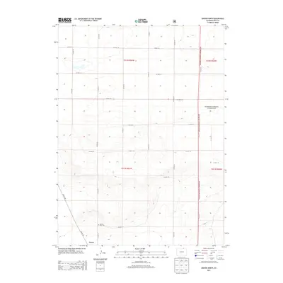
2013 Map of Grover North
USGS Topo · Published 2013About this map
Grover sits at the southern edge of this high plains landscape, situated near the corner of Co Road 126 and Co Road 87. The area is characterized by a precise grid of rural thoroughfares, such as Co Road 138 and Co Road 93, which partition the territory into large agricultural and grazing sections typical of the Weld County region. A significant portion of the eastern landscape is designated as part of the Pawnee National Grassland, emphasizing the conservation and open-range character of the territory. Of particular interest to genealogists and local historians is the Home of Peace Cem, a solitary landmark located north of the town center. The map reflects a modern era where the traditional township and range system remains the primary organizational structure for land use and navigation.
Find a feature on this map
23 named features on this map. Tap any name to fly to it.
Don’t see what you’re looking for? This feature index may not catch every label — zoom into the map to look around manually.
Map Details
Editions of this 2013 Grover North Map
This is the sole edition of this map. No revisions or reprints were ever made.
Other maps of this area
1954 · Cheyenne
USGS Topo · 1:250,000
1954 · Greeley
USGS Topo · 1:250,000
1957 · Greeley
USGS Topo · 1:250,000
1958 · Cheyenne
USGS Topo · 1:250,000
1958 · Greeley
USGS Topo · 1:250,000
1961 · Greeley
USGS Topo · 1:250,000
1963 · Pine Bluffs SE
USGS Topo · 1:24,000
1963 · Carpenter
USGS Topo · 1:24,000
1963 · Pine Bluffs SW
USGS Topo · 1:24,000
1964 · Greeley
USGS Topo · 1:250,000