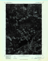
1975 Map of Guilford SE
USGS Topo · Published 1980About this map
Center Pond dominates the southern landscape of this 1975 orthophotograph, providing a stark visual contrast between the deep waters and the surrounding agricultural patchwork of Penobscot County. The aerial imagery captures the rural character of the Maine woods and farmland during the mid-1970s, revealing the precise arrangement of homesteads and fields. Smaller crossroads and settlements like North Dexter and Gilman Corner appear as clusters of activity along the established road network, while Spooners Mill sits to the south. Because this is an orthophotoquad, it offers a literal photographic record of the land use, timber stands, and clearing patterns that standard topographic lines can only approximate, making it an essential resource for understanding the mid-century Maine countryside.
Find a feature on this map
4 named features on this map. Tap any name to fly to it.
Don’t see what you’re looking for? This feature index may not catch every label — zoom into the map to look around manually.
Map Details
Editions of this 1975 Guilford SE Map
This is the sole edition of this map. No revisions or reprints were ever made.
Other maps of this area

1930 · Pittsfield
USGS Topo · 1:48,000

1931 · Stetson
USGS Topo · 1:48,000

1932 · Dover-Foxcroft
USGS Topo · 1:48,000

1932 · Pittsfield
USGS Topo · 1:62,500

1933 · Pittsfield
USGS Topo · 1:62,500

1933 · Guilford
USGS Topo · 1:62,500

1935 · Dover-Foxcroft
USGS Topo · 1:62,500

1935 · Stetson
USGS Topo · 1:62,500

1937 · Guilford
USGS Topo · 1:62,500

1948 · Bangor
USGS Topo · 1:250,000