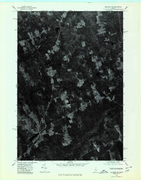
1975 Map of Guilford SW
USGS Topo · Published 1980About this map
Cambridge and the surrounding woodlands of Somerset and Piscataquis counties are captured here in a 1975 aerial orthophotograph, providing a rare visual record of the central Maine landscape before modern development. Unlike traditional line-drawn maps, this survey uses rectified photography to reveal the exact footprint of forest clearings, farm plots, and road networks. The settlement of Pingree Center appears as a distinct cluster of structures amidst the dense canopy, while the winding course of the Sebasticook and the Main Stream cut through the terrain. This specific format is particularly valuable for local historians and land researchers, as it documents the precise state of rural property boundaries and timber activity at the mid-decade mark, showing the texture of the Maine woods with photographic clarity.
Find a feature on this map
4 named features on this map. Tap any name to fly to it.
Don’t see what you’re looking for? This feature index may not catch every label — zoom into the map to look around manually.
Map Details
Editions of this 1975 Guilford SW Map
This is the sole edition of this map. No revisions or reprints were ever made.
Other maps of this area

1913 · Skowhegan
USGS Topo · 1:62,500

1930 · Pittsfield
USGS Topo · 1:48,000

1932 · Pittsfield
USGS Topo · 1:62,500

1933 · Pittsfield
USGS Topo · 1:62,500

1933 · Guilford
USGS Topo · 1:62,500

1937 · Guilford
USGS Topo · 1:62,500

1948 · Bangor
USGS Topo · 1:250,000

1948 · Kingsbury
USGS Topo · 1:62,500

1950 · Kingsbury
USGS Topo · 1:62,500

1954 · Millinocket
USGS Topo · 1:250,000