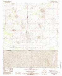
1985 Map of Guzmans Lookout Mountain
USGS Topo · Published 1985About this map
The international border between United States of America and Mexico bisects this arid terrain in Doña Ana Co, New Mexico. Dominating the landscape are the West Potrillo Mountains, a volcanic field characterized by numerous cinder cones and lava flows that define the northern half of the sheet. Rising prominently from the desert floor, Guzmans Lookout Mountain serves as a stark topographical landmark just north of the border line. To the south, within the state of Chihuahua, the settlement of La Peña sits amidst the sparsely populated high desert. The map captures the remote boundary region as it was recorded during the mid-1980s, documenting the physical division between New Mexico and Chihuahua.
Find a feature on this map
6 named features on this map. Tap any name to fly to it.
Don’t see what you’re looking for? This feature index may not catch every label — zoom into the map to look around manually.
Map Details
Editions of this 1985 Guzmans Lookout Mountain Map
This is the sole edition of this map. No revisions or reprints were ever made.
Other maps of this area

1917 · Camel Mountain
USGS Topo · 1:62,500

1917 · Mt. Riley
USGS Topo · 1:62,500

1918 · Mt. Riley
USGS Topo · 1:62,500

1929 · Mt. Riley
USGS Topo · 1:62,500

1951 · Mt. Riley
USGS Topo · 1:62,500

1953 · El Paso
USGS Topo · 1:250,000

1959 · El Paso
USGS Topo · 1:250,000

1964 · El Paso
USGS Topo · 1:250,000

1965 · El Paso
USGS Topo · 1:250,000
1965 · Camel Mountain
USGS Topo · 1:24,000