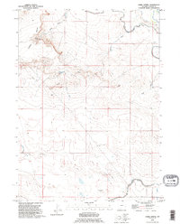
1990 Map of Habig Spring
USGS Topo · Published 1995About this map
The historical Emigrant Trail traverses the northeastern corner of this landscape, marking a legacy of westward expansion across the high plains of Wyoming. This 1990 revision, based on imagery dating back to 1957, details a high-desert terrain defined by the sharp escarpment of the South Rim and the prominent Harmony Heights. The map documents the vital importance of water in this arid region, showing the Laramie Canal and the Emigrant Ditch alongside natural features like Habig Spring and Sandercock Spring.
Find a feature on this map
20 named features on this map. Tap any name to fly to it.
Don’t see what you’re looking for? This feature index may not catch every label — zoom into the map to look around manually.
Map Details
Editions of this 1990 Habig Spring Map
This is the sole edition of this map. No revisions or reprints were ever made.
Other maps of this area

1896 · Patrick
USGS Topo · 1:125,000

1896 · Hartville
USGS Topo · 1:125,000

1899 · Goshen Hole
USGS Topo · 1:125,000

1901 · Hartville
USGS Topo · 1:125,000

1950 · Rockeagle
USGS Topo · 1:24,000

1950 · Fort Laramie
USGS Topo · 1:24,000

1952 · Fort Laramie
USGS Topo · 1:24,000

1954 · Torrington
USGS Topo · 1:250,000

1954 · Cheyenne
USGS Topo · 1:250,000

1958 · Cheyenne
USGS Topo · 1:250,000