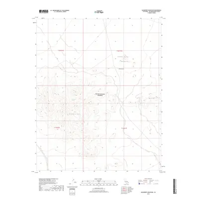
2018 Map of Hackberry Mountain
USGS Topo · Published 2018About this map
Hackberry Mtn dominates this high-desert landscape, serving as a prominent landmark within the southern reaches of the Mojave National Preserve. This 2018 survey documents a region defined by its vital water sources in an otherwise arid environment, specifically Hackberry Spring and Vontrigger Spring, which have historically supported local wildlife and travelers through the Mojave Desert. The topography transitions from the alluvial plains of Lanfair Valley into the elevated terrain of the Bobcat Hills and Vontrigger Hills. Drainage patterns are clearly defined by the course of Watson Wash, which cuts through the southern portion of the quadrangle. This map is an essential reference for understanding the modern conservation boundaries and natural hydrology of this portion of San Bernardino County, where the relationship between scarce springs and prominent peaks continues to shape the character of the eastern Mojave.
Find a feature on this map
13 named features on this map. Tap any name to fly to it.
Don’t see what you’re looking for? This feature index may not catch every label — zoom into the map to look around manually.
Map Details
Editions of this 2018 Hackberry Mountain Map
This is the sole edition of this map. No revisions or reprints were ever made.
Other maps of this area

1910 · Ivanpah
USGS Topo · 1:250,000

1912 · Ivanpah
USGS Topo · 1:250,000

1942 · Ivanpah
USGS Topo · 1:250,000

1942 · Amboy
USGS Topo · 1:250,000

1943 · Amboy
USGS Topo · 1:250,000

1943 · Fenner
USGS Topo · 1:62,500

1947 · Kingman
USGS Topo · 1:250,000

1948 · Kingman
USGS Topo · 1:250,000

1954 · Needles
USGS Topo · 1:250,000

1954 · Kingman
USGS Topo · 1:250,000