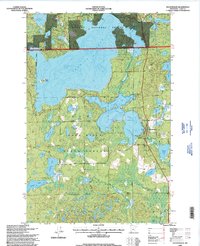
1996 Map of Hackensack
USGS Topo · Published 1998About this map
Ten Mile Lake and the interconnected waters of Birch Lake dominate this mid-1990s survey of north-central Minnesota. The village of Hackensack is positioned as a gateway between these waters and the extensive public lands of the Chippewa National Forest and Foot Hills State Forest. This landscape is defined by its glacial heritage, characterized by dozens of named basins including Paquet Lake, Hiram Lake, and Jackpine Lake.
Find a feature on this map
27 named features on this map. Tap any name to fly to it.
Don’t see what you’re looking for? This feature index may not catch every label — zoom into the map to look around manually.
Map Details
Editions of this 1996 Hackensack Map
This is the sole edition of this map. No revisions or reprints were ever made.
Other maps of this area

1953 · Brainerd
USGS Topo · 1:250,000

1954 · Bemidji
USGS Topo · 1:250,000

1957 · Brainerd
USGS Topo · 1:250,000

1957 · Bemidji
USGS Topo · 1:250,000

1958 · Bemidji
USGS Topo · 1:250,000

1958 · Brainerd
USGS Topo · 1:250,000

1965 · Brainerd
USGS Topo · 1:250,000

1970 · Backus
USGS Topo · 1:24,000

1970 · Hackensack
USGS Topo · 1:24,000
1970 · Mildred
USGS Topo · 1:24,000