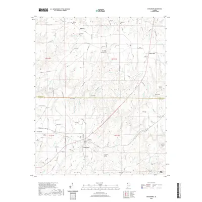
2020 Map of Hackleburg
USGS Topo · Published 2020About this map
Hackleburg serves as the central hub for this portion of northwest Alabama, where the Tennessee Valley Divide separates local drainage systems. The landscape is defined by the winding course of Bear Creek and its many tributaries, such as Wildcat Br and Dismal Br. This 2020 map documents the enduring network of rural settlements including Duketon, Nix, and Wiginton, alongside numerous family burial grounds like Cochran Family Cem and Edgar Cem.
Find a feature on this map
164 named features on this map. Tap any name to fly to it.
Don’t see what you’re looking for? This feature index may not catch every label — zoom into the map to look around manually.
Map Details
Editions of this 2020 Hackleburg Map
This is the sole edition of this map. No revisions or reprints were ever made.
Other maps of this area

1936 · Hodges
USGS Topo · 1:24,000

1936 · Isbell
USGS Topo · 1:24,000

1936 · Phil Campbell
USGS Topo · 1:24,000

1936 · South Of Hackleburg
USGS Topo · 1:24,000

1936 · Hackleburg
USGS Topo · 1:24,000

1936 · Spruce Pine
USGS Topo · 1:24,000

1936 · Goddard
USGS Topo · 1:24,000

1936 · Guinn Cross Roads
USGS Topo · 1:24,000

1945 · Spruce Pine
USGS Topo · 1:24,000
1945 · Isbell
USGS Topo · 1:24,000