
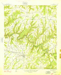
1936 Map of Goddard
USGS Topo · Published 1936About this map
The Tennessee Basin Divide cuts through this 1936 survey, marking a significant hydrological boundary in the terrain south of the Tennessee River. This high ground separates the watersheds of Brush Creek and Flat Creek, influencing the settlement patterns and transportation corridors of the era. The mapping, coordinated by the Tennessee Valley Authority and the U.S. Geological Survey, highlights the strategic importance of the Southern and Illinois Central No 5 railroads as they traverse this ridge-dominated landscape.
Find a feature on this map
13 named features on this map. Tap any name to fly to it.
Don’t see what you’re looking for? This feature index may not catch every label — zoom into the map to look around manually.
Map Details
Editions of this 1936 Goddard Map
This is the sole edition of this map. No revisions or reprints were ever made.
Other maps of this area

1936 · Delmar
USGS Topo · 1:24,000

1936 · Kinlock Spring
USGS Topo · 1:24,000

1936 · Phil Campbell
USGS Topo · 1:24,000

1936 · South Of Hackleburg
USGS Topo · 1:24,000

1936 · Hackleburg
USGS Topo · 1:24,000

1946 · Hackleburg
USGS Topo · 1:24,000

1946 · Phil Campbell
USGS Topo · 1:24,000

1947 · Phil Campbell
USGS Topo · 1:24,000

1947 · Kinlock Spring
USGS Topo · 1:24,000
1948 · Hackleburg
USGS Topo · 1:24,000