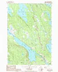
1987 Map of Hadley Lake
USGS Topo · Published 1988About this map
Jacksonville sits at the convergence of the East Machias River and Gardner Lake, serving as the primary node of settlement in this part of Washington County. The landscape is defined by an extensive freshwater network, including the expansive Hadley Lake and the smaller Lily Lake and Marks Lake to the south. The terrain shows a transition from the marshy lowlands of Berry Heath and Crocker Brook to the elevated spine of Rocky Ridge. Resource extraction and land management are evident through the presence of Gravel Pits and the clearly defined borders of No 14 Plt and T 18 Ed BPP. This survey provides a clear view of the rural infrastructure during the late 1980s, documenting local landmarks like the Cem in Jacksonville and the winding course of Marion Stream.
Find a feature on this map
27 named features on this map. Tap any name to fly to it.
Don’t see what you’re looking for? This feature index may not catch every label — zoom into the map to look around manually.
Map Details
Editions of this 1987 Hadley Lake Map
This is the sole edition of this map. No revisions or reprints were ever made.
Other maps of this area

1918 · Machias
USGS Topo · 1:62,500

1921 · Columbia Falls
USGS Topo · 1:62,500

1941 · Columbia Falls
USGS Topo · 1:62,500

1941 · Machias
USGS Topo · 1:62,500

1941 · Wesley
USGS Topo · 1:62,500

1941 · Gardner Lake
USGS Topo · 1:62,500

1942 · Columbia Falls
USGS Topo · 1:62,500

1943 · Wesley
USGS Topo · 1:62,500

1943 · Gardner Lake
USGS Topo · 1:62,500
1948 · Whitneyville
USGS Topo · 1:24,000