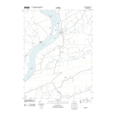
2010 Map of Halifax
USGS Topo · Published 2010About this map
The Susquehanna River dominates this landscape, its wide channel punctuated by substantial islands such as Clemson Island, Lingle Island, and Bressler Island. Along the eastern bank, the town of Halifax serves as a central hub, while the smaller settlement of New Buffalo sits across the water near Girtys Notch. The geography is defined by a series of parallel creeks—Armstrong Creek, Powells Creek, and Clark Creek—that carve through the terrain toward the river. Local landmarks like Walsh Airport and Camp Hebron illustrate the mix of transportation and community spaces in the region. For those researching family history, the map includes sites like Zion Cemetery and Highland Cemetery, while the Peters Mountain Overlook highlights the higher elevations that bound the river valley to the south.
Find a feature on this map
61 named features on this map. Tap any name to fly to it.
Don’t see what you’re looking for? This feature index may not catch every label — zoom into the map to look around manually.
Map Details
Editions of this 2010 Halifax Map
This is the sole edition of this map. No revisions or reprints were ever made.
Other maps of this area

1892 · Harrisburg
USGS Topo · 1:62,500

1893 · Millersburg
USGS Topo · 1:62,500

1899 · Harrisburg
USGS Topo · 1:62,500

1907 · New Bloomfield
USGS Topo · 1:62,500

1907 · Millerstown
USGS Topo · 1:62,500

1924 · Harrisburg
USGS Topo · 1:62,500

1943 · Millerstown
USGS Topo · 1:62,500

1943 · Millersburg
USGS Topo · 1:62,500

1943 · Harrisburg
USGS Topo · 1:62,500

1943 · New Bloomfield
USGS Topo · 1:62,500
Featured Places
- New Buffalo, PA
- Reed Township, PA
- Watts Township, PA
- Half Falls, Watts Township
- Singersville, Middle Paxton Township