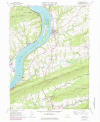
1977 Map of Halifax
USGS Topo · Published 1984About this map
The Susquehanna River dominates this landscape, its wide waters punctuated by prominent landforms like Clemson Island and Haldeman Island. Along the eastern shore, the borough of Halifax stands as a focal point of commerce and settlement, while the Conrail line traces the riverbank, marking the essential transportation corridor of the era. To the south, the topography shifts into a series of dramatic ridges, including Peters Mountain and Third Mountain, which are traversed by the legendary Appalachian Trail.
Find a feature on this map
56 named features on this map. Tap any name to fly to it.
Don’t see what you’re looking for? This feature index may not catch every label — zoom into the map to look around manually.
Map Details
Editions of this 1977 Halifax Map
This is the sole edition of this map. No revisions or reprints were ever made.
Other maps of this area

1892 · Harrisburg
USGS Topo · 1:62,500

1893 · Millersburg
USGS Topo · 1:62,500

1899 · Harrisburg
USGS Topo · 1:62,500

1907 · New Bloomfield
USGS Topo · 1:62,500

1907 · Millerstown
USGS Topo · 1:62,500

1924 · Harrisburg
USGS Topo · 1:62,500

1943 · Millerstown
USGS Topo · 1:62,500

1943 · Millersburg
USGS Topo · 1:62,500

1943 · Harrisburg
USGS Topo · 1:62,500

1943 · New Bloomfield
USGS Topo · 1:62,500