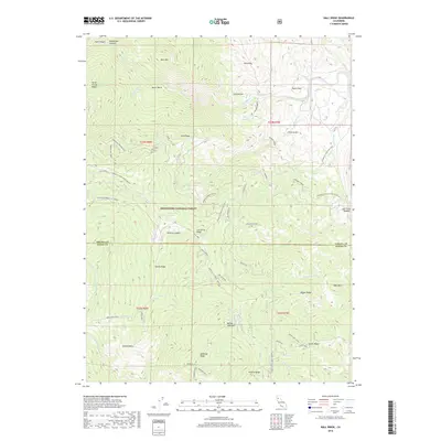
2018 Map of Hall Ridge
USGS Topo · Published 2018About this map
Mendocino National Forest defines this high-elevation landscape along the boundary of Tehama and Glenn counties. The terrain is characterized by a series of prominent northwest-trending divides, including Hall Ridge, Horse Trough Ridge, and Daves Ridge, separated by deep drainages such as Thomes Cr and Salt Cr. Human presence is marked by isolated sites like Houghton Place and a network of forest routes, most notably the Tehama Co. Road (Round Valley) and the Paskenta-Mendocino Pass. Water sources are vital in this environment, with locations like Commissary Spring, Daves Spring, and Valley View Spring providing essential points of interest for those navigating the backcountry. Geologic and topographic features with distinctive names like Dead Rabbit, Gunsight, and Scotts Glade suggest a landscape shaped by early surveyors and ranching history.
Find a feature on this map
51 named features on this map. Tap any name to fly to it.
Don’t see what you’re looking for? This feature index may not catch every label — zoom into the map to look around manually.
Map Details
Editions of this 2018 Hall Ridge Map
This is the sole edition of this map. No revisions or reprints were ever made.
Other maps of this area

1919 · Elk Creek
USGS Topo · 1:62,500

1948 · Elk Creek
USGS Topo · 1:62,500

1952 · Paskenta
USGS Topo · 1:62,500

1952 · Hull Mountain
USGS Topo · 1:62,500

1952 · Anthony Peak
USGS Topo · 1:62,500

1957 · Elk Creek
USGS Topo · 1:62,500

1957 · Ukiah
USGS Topo · 1:250,000

1960 · Ukiah
USGS Topo · 1:250,000
1967 · Plaskett meadows
USGS Topo · 1:24,000
1967 · Log Spring
USGS Topo · 1:24,000