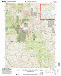
1996 Map of Hall Ridge
USGS Topo · Published 2001About this map
Mendocino National Forest defines the rugged verticality of this region, spanning the border of Tehama and Glenn counties. The landscape is marked by high elevations like Valley View Mountain and the deep cut of Thomas Gorge, while numerous small-scale agricultural holdings and homesteads are scattered across the ridges and gulches. Named landmarks such as Whitlock Place, Davies Orchard, and Conklin Orchard indicate a legacy of remote orcharding and ranching, often situated near vital water sources like Buck Spring or Daves Spring. Movement through this terrain in the mid-1990s relied heavily on a network of 4wd tracks and forest roads, connecting isolated spots like Black Bear Camp and Del Matteson Spr Camp to the larger drainages of Thomes Creek and Grindstone Creek. This survey captures a moment of established forest management and high-country ranching before modern shifts in land use and accessibility.
Find a feature on this map
53 named features on this map. Tap any name to fly to it.
Don’t see what you’re looking for? This feature index may not catch every label — zoom into the map to look around manually.
Map Details
Editions of this 1996 Hall Ridge Map
This is the sole edition of this map. No revisions or reprints were ever made.
Other maps of this area

1919 · Elk Creek
USGS Topo · 1:62,500

1948 · Elk Creek
USGS Topo · 1:62,500

1952 · Paskenta
USGS Topo · 1:62,500

1952 · Hull Mountain
USGS Topo · 1:62,500

1952 · Anthony Peak
USGS Topo · 1:62,500

1957 · Elk Creek
USGS Topo · 1:62,500

1957 · Ukiah
USGS Topo · 1:250,000

1960 · Ukiah
USGS Topo · 1:250,000
1967 · Plaskett meadows
USGS Topo · 1:24,000
1967 · Log Spring
USGS Topo · 1:24,000