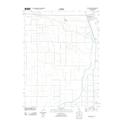
2012 Map of Hamilton City
USGS Topo · Published 2012About this map
Hamilton City stands as the primary settlement in this agricultural corridor of the Sacramento Valley during the early 2010s. The landscape is defined by its sophisticated irrigation and water management systems, most notably the Glenn-Colusa Canal which snakes through the eastern half of the quadrangle. Small agrarian nodes such as Mills Orchard and Saint John punctuate the grid of county roads, reflecting a long-standing pattern of orchard cultivation and river-adjacent settlement. The meandering path of Stony Cr cuts across the northern terrain, creating a natural contrast to the rigid geometry of the surrounding fields. Transportation and logistics are central to the area's layout, anchored by Old Hwy 32 and the Co Rd Railroad corridor. Further south, the map traces the rural footprints of Rotavele and Ordbend, where the land-use patterns emphasize the region's reliance on the fertile soils near the Sacramento River basin.
Find a feature on this map
44 named features on this map. Tap any name to fly to it.
Don’t see what you’re looking for? This feature index may not catch every label — zoom into the map to look around manually.
Map Details
Editions of this 2012 Hamilton City Map
This is the sole edition of this map. No revisions or reprints were ever made.
Other maps of this area

1891 · Chico
USGS Topo · 1:125,000

1893 · Chico
USGS Topo · 1:125,000

1895 · Chico
USGS Topo · 1:125,000

1904 · Vina
USGS Topo · 1:62,500

1906 · Willows
USGS Topo · 1:62,500

1912 · Nord
USGS Topo · 1:31,680

1912 · Chico Landing
USGS Topo · 1:31,680
1912 · Newhard
USGS Topo · 1:31,680

1914 · Kirkwood
USGS Topo · 1:31,680

1914 · Orland
USGS Topo · 1:31,680