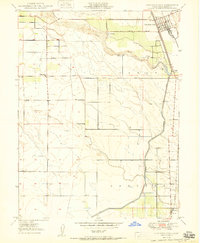
1950 Map of Hamilton City
USGS Topo · Published 1950About this map
Hamilton City serves as the focal point of this 1950 landscape, situated along the Southern Pacific railroad line where industry and agriculture meet. The northern reach of the quadrangle is defined by the winding course of Stony Creek, which provides a natural boundary near the Mills Orchard and the associated Mills Orchard Road. This survey captures the region's essential water management system, anchored by the Central Irrigation Canal that bisects the ranch lands of Jacinto and Capay. Further south, the map documents the rural communities of Ordbend and the historic St John (Site). Educational hubs are clearly marked, including the Union High Sch serving the town center, and outlying rural facilities like Plaza School and Ord School, reflecting the era's decentralized agricultural settlement pattern.
Find a feature on this map
17 named features on this map. Tap any name to fly to it.
Don’t see what you’re looking for? This feature index may not catch every label — zoom into the map to look around manually.
Map Details
Editions of this 1950 Hamilton City Map
This is the sole edition of this map. No revisions or reprints were ever made.
Other maps of this area

1891 · Chico
USGS Topo · 1:125,000

1893 · Chico
USGS Topo · 1:125,000

1895 · Chico
USGS Topo · 1:125,000

1904 · Vina
USGS Topo · 1:62,500

1906 · Willows
USGS Topo · 1:62,500

1912 · Nord
USGS Topo · 1:31,680

1912 · Chico Landing
USGS Topo · 1:31,680
1912 · Newhard
USGS Topo · 1:31,680

1914 · Kirkwood
USGS Topo · 1:31,680

1914 · Orland
USGS Topo · 1:31,680