
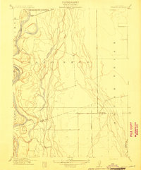
1914 Map of Hamilton
USGS Topo · Published 1914About this map
Hamilton and the surrounding river bottomlands of Stony Creek dominate this 1904 survey of northeastern Glenn County. The landscape is defined by the early implementation of the Central Irrigation Canal, which cuts through the agricultural districts of Capay and Jacinto. This infrastructure reflects a pivotal transition for the Sacramento Valley, as dry-land ranching began to give way to irrigated agriculture. Transport is clustered at the north, where the S P R R and Northern El R R serve the local grain and produce economy. Near the river, the Swift Point Warehouse and the small settlement of St John mark historical points of river-based commerce and storage before rail dominated the valley's transit. The map provides an intimate look at the land division and hydraulic engineering that shaped this part of California at the dawn of the twentieth century.
Find a feature on this map
9 named features on this map. Tap any name to fly to it.
Don’t see what you’re looking for? This feature index may not catch every label — zoom into the map to look around manually.
Map Details
Editions of this 1914 Hamilton Map
This is the sole edition of this map. No revisions or reprints were ever made.
Other maps of this area

1891 · Chico
USGS Topo · 1:125,000

1893 · Chico
USGS Topo · 1:125,000

1895 · Chico
USGS Topo · 1:125,000

1904 · Vina
USGS Topo · 1:62,500

1906 · Willows
USGS Topo · 1:62,500

1912 · Nord
USGS Topo · 1:31,680

1912 · Chico Landing
USGS Topo · 1:31,680
1912 · Newhard
USGS Topo · 1:31,680

1914 · Kirkwood
USGS Topo · 1:31,680

1914 · Orland
USGS Topo · 1:31,680