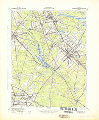
1942 Map of Hammonton
USGS Topo · Published 1942About this map
Hammonton serves as the primary hub of this South Jersey landscape, situated at the crossroads of the Reading Lines and several significant regional thoroughfares like the White Horse Road. The area is defined by a dense network of watercourses, including the Great Egg Harbor River and numerous tributaries such as the Hospitality Branch and Sleeper Branch. This intricate drainage pattern suggests a geography of low-lying wetlands and cranberry bogs, typical of the Pine Barrens, interspersed with agricultural activity.
Find a feature on this map
90 named features on this map. Tap any name to fly to it.
Don’t see what you’re looking for? This feature index may not catch every label — zoom into the map to look around manually.
Map Details
Editions of this 1942 Hammonton Map
This is the sole edition of this map. No revisions or reprints were ever made.
Other maps of this area

1888 · Pemberton
USGS Topo · 1:62,500

1888 · Mount Holly
USGS Topo · 1:62,500

1890 · Great Egg Harbor
USGS Topo · 1:62,500

1890 · Hammonton
USGS Topo · 1:62,500

1890 · Tuckahoe
USGS Topo · 1:62,500

1890 · Bridgeton
USGS Topo · 1:62,500

1890 · Mullica
USGS Topo · 1:62,500

1890 · Glassboro
USGS Topo · 1:62,500

1891 · Philadelphia
USGS Topo · 1:62,500

1893 · Great Egg Harbor
USGS Topo · 1:62,500