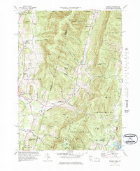
1973 Map of Hancock
USGS Topo · Published 1984About this map
The Taconic Mountains form the spine of this borderland, where the state line between New York and Massachusetts cuts across high ridges like Misery Mountain and Potter Mtn. This mid-century landscape is defined by its recreation and conservation history, featuring the Brodie Mtn Ski Area and Jiminy Peak Ski Area alongside the expansive Pittsfield State Forest. To the west, the village of Stephentown and its surrounding hamlets like North Stephentown are connected by an Old RR Grade, tracing the valley of Wyomanock Creek. Local life in the hollows is marked by essential community landmarks such as Hancock Central Sch and the St Josephs Cem near the Kinderhook Creek. The terrain remains largely protected, with the Forbush Wildlife Sanctuary and Balance Rock State Park preserving the high-elevation wetlands of Berry Pond.
Find a feature on this map
84 named features on this map. Tap any name to fly to it.
Don’t see what you’re looking for? This feature index may not catch every label — zoom into the map to look around manually.
Map Details
Editions of this 1973 Hancock Map
3 editions found
Other maps of this area

1886 · Greylock
USGS Topo · 1:62,500

1886 · Becket
USGS Topo · 1:62,500

1888 · Becket
USGS Topo · 1:62,500

1888 · Berlin
USGS Topo · 1:62,500

1888 · Pittsfield
USGS Topo · 1:62,500

1890 · Pittsfield
USGS Topo · 1:62,500

1890 · Berlin
USGS Topo · 1:62,500

1891 · Greylock
USGS Topo · 1:62,500

1893 · Becket
USGS Topo · 1:62,500

1893 · Greylock
USGS Topo · 1:62,500