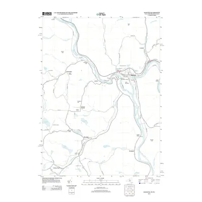
2013 Map of Hancock
USGS Topo · Published 2013About this map
The West Br Delaware River and East Br Delaware River meet at the village of Hancock, a significant geographic junction where the main stem of the Delaware River begins its journey south. This 2013 survey details the village's historic core, including the Old Village Community Cem and the Hancock - Buckingham Bridge connecting the New York and Pennsylvania border. The landscape is defined by the surrounding heights of Point Mountain and Coon Hill, which channel numerous tributaries like Sands Cr and Cadosia Cr toward the river valley. To the south, smaller settlements like Starlight and Preston Park sit among a high-elevation plateau dotted with water bodies such as Starlight Lake and Hempstead Lake. The presence of the Initial Monument in the northwest corner near Hawks Nest marks a critical point in the regional survey history.
Find a feature on this map
86 named features on this map. Tap any name to fly to it.
Don’t see what you’re looking for? This feature index may not catch every label — zoom into the map to look around manually.
Map Details
Editions of this 2013 Hancock Map
This is the sole edition of this map. No revisions or reprints were ever made.
Other maps of this area

1920 · Long Eddy
USGS Topo · 1:62,500

1921 · Long Eddy
USGS Topo · 1:48,000

1923 · Long Eddy
USGS Topo · 1:62,500

1923 · Walton
USGS Topo · 1:48,000

1924 · Starrucca
USGS Topo · 1:48,000

1924 · Deposit
USGS Topo · 1:62,500

1925 · Walton
USGS Topo · 1:62,500

1926 · Deposit
USGS Topo · 1:62,500

1926 · Starrucca
USGS Topo · 1:62,500

1930 · Starrucca
USGS Topo · 1:48,000