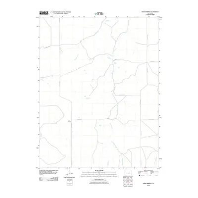
2010 Map of Hand Springs
USGS Topo · Published 2010About this map
Bethel Cemetery sits at the intersection of County Rd 24 and County Road L 0, serving as a quiet focal point in this sparsely populated stretch of Bent County. The landscape is defined by its vital water sources, with named sites such as Hand Springs, Chimney Spring, and Santastevens Spring dotting the terrain. These springs likely dictated the placement of early ranching infrastructure and local roads in a region where water is a precious commodity. A network of ephemeral waterways, including Antelope Creek and the meandering West Mud Creek, carve through the plains. The map illustrates a high-desert environment structured by a rigid grid of rural routes like County Rd 23 and County Rd 28, connecting isolated landmarks such as Medford Spring and Box Springs across the open range.
Find a feature on this map
18 named features on this map. Tap any name to fly to it.
Don’t see what you’re looking for? This feature index may not catch every label — zoom into the map to look around manually.
Map Details
Editions of this 2010 Hand Springs Map
This is the sole edition of this map. No revisions or reprints were ever made.
Other maps of this area

1891 · Higbee
USGS Topo · 1:125,000

1892 · Two Butte
USGS Topo · 1:125,000

1893 · Higbee
USGS Topo · 1:125,000

1893 · Two Butte
USGS Topo · 1:125,000

1955 · La Junta
USGS Topo · 1:250,000

1958 · La Junta
USGS Topo · 1:250,000

1966 · Toonerville SE
USGS Topo · 1:24,000
1966 · Toonerville NE
USGS Topo · 1:24,000

1967 · Hand Springs
USGS Topo · 1:24,000

1968 · La Junta
USGS Topo · 1:250,000