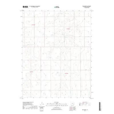
2019 Map of Hand Springs
USGS Topo · Published 2019About this map
Antelope Spring and a series of high-plains water sources anchor this remote landscape in Bent County, where the high desert terrain is carved by ephemeral drainages. The distribution of Santastevens Spring, Medford Spring, and Hand Springs suggests the critical importance of reliable water for livestock and early ranching in this arid stretch of Colorado. Evidence of past community life appears at the Antelope School and the Bethel Cem located along Co RD 24. These landmarks, along with named waterways like Antelope Cr and Little Angry Cr, provide a framework for understanding the sparse settlement patterns that have persisted through the modern era. The survey also details the section lines and township boundaries of T25S and T26S, illustrating the geometric precision of the Public Land Survey System in the American West.
Find a feature on this map
22 named features on this map. Tap any name to fly to it.
Don’t see what you’re looking for? This feature index may not catch every label — zoom into the map to look around manually.
Map Details
Editions of this 2019 Hand Springs Map
This is the sole edition of this map. No revisions or reprints were ever made.
Other maps of this area

1891 · Higbee
USGS Topo · 1:125,000

1892 · Two Butte
USGS Topo · 1:125,000

1893 · Higbee
USGS Topo · 1:125,000

1893 · Two Butte
USGS Topo · 1:125,000

1955 · La Junta
USGS Topo · 1:250,000

1958 · La Junta
USGS Topo · 1:250,000

1966 · Toonerville SE
USGS Topo · 1:24,000
1966 · Toonerville NE
USGS Topo · 1:24,000

1967 · Hand Springs
USGS Topo · 1:24,000

1968 · La Junta
USGS Topo · 1:250,000