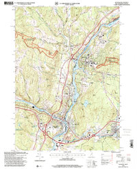
1996 Map of Hanover
USGS Topo · Published 2001About this map
The Connecticut River serves as the central artery and state boundary in this detailed 1990s look at the Upper Valley. Dominating the eastern shore is the sprawling campus of Dartmouth College in Hanover, while the western bank features the hillside settlements of Norwich and Wilder. The landscape is a mix of academic tradition, industrial history, and preservation, with the Appalachian Scenic Trail winding through the Green Mountain National Forest to the west and the White Mountain National Forest to the east.
Find a feature on this map
76 named features on this map. Tap any name to fly to it.
Don’t see what you’re looking for? This feature index may not catch every label — zoom into the map to look around manually.
Map Details
Editions of this 1996 Hanover Map
This is the sole edition of this map. No revisions or reprints were ever made.
Other maps of this area

1896 · Strafford
USGS Topo · 1:62,500

1906 · Hanover
USGS Topo · 1:62,500

1908 · Hanover
USGS Topo · 1:62,500

1927 · Mascoma
USGS Topo · 1:62,500

1931 · Mt. Cube
USGS Topo · 1:62,500

1932 · Mascoma
USGS Topo · 1:62,500

1933 · Mt. Cube
USGS Topo · 1:62,500

1944 · Strafford
USGS Topo · 1:62,500

1950 · Glens Falls
USGS Topo · 1:250,000

1956 · Glens Falls
USGS Topo · 1:250,000