1949 Map of Hanover
USGS Topo · Published 1967About this map
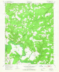
The Pamunkey River defines the southern portion of this landscape, winding through a borderland where Hanover, Caroline, and King William counties meet. In the late 1940s, this region remained heavily agricultural and institutional, anchored by the Virginia Industrial School for Boys and the State Convict Camp. Small rural crossroads and settlement nodes like Mangohick and Dawn are mapped in detail, each supported by local institutions such as Mangohick Sch and Dawn Sch.
Find a feature on this map
49 named features on this map. Tap any name to fly to it.
Don’t see what you’re looking for? This feature index may not catch every label — zoom into the map to look around manually.
Map Details
Editions of this 1949 Hanover Map
This is the sole edition of this map. No revisions or reprints were ever made.
Other maps of this area

1894 · Richmond
USGS Topo · 1:62,500

1895 · Richmond
USGS Topo · 1:62,500

1918 · Doswell
USGS Topo · 1:62,500

1918 · Aylett
USGS Topo · 1:62,500

1920 · King William
USGS Topo · 1:62,500

1933 · Aylett
USGS Topo · 1:62,500
1938 · Studley
USGS Topo · 1:31,680

1938 · Yellow Tavern
USGS Topo · 1:31,680

1943 · Richmond
USGS Topo · 1:250,000

1949 · Richmond
USGS Topo · 1:250,000