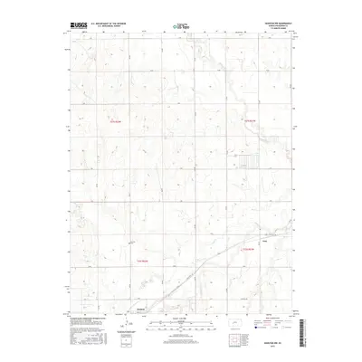
2015 Map of Hanston NW
USGS Topo · Published 2015About this map
Hanston sits at the southern edge of this West Central Kansas landscape, where the agricultural grid of Hodgeman County meets a winding network of prairie waterways. The town plan is anchored by Adams St and positioned near the confluence of local drainages like Buckner Creek and Dry Creek. To the north, the terrain is defined by the larger meanders of the Pawnee River, which cuts a distinct path through the systematic section lines. The map reveals a transition from the structured township system, including boundaries like t21s r22w and t22s r21w, to the natural riparian corridors. For those tracing local history or family roots, the Hanston Cemetery remains a key landmark north of the town center, while State Hwy 156 serves as the primary modern thoroughfare connecting this rural community to the surrounding plains.
Find a feature on this map
21 named features on this map. Tap any name to fly to it.
Don’t see what you’re looking for? This feature index may not catch every label — zoom into the map to look around manually.
Map Details
Editions of this 2015 Hanston NW Map
This is the sole edition of this map. No revisions or reprints were ever made.
Other maps of this area

1892 · Ness
USGS Topo · 1:125,000

1894 · Ness
USGS Topo · 1:125,000

1955 · Great Bend
USGS Topo · 1:250,000

1957 · Great Bend
USGS Topo · 1:250,000

1958 · Great Bend
USGS Topo · 1:250,000

1970 · Jetmore SE
USGS Topo · 1:24,000
1970 · Hanston
USGS Topo · 1:24,000

1970 · Hanston NW
USGS Topo · 1:24,000

1970 · Jetmore NE
USGS Topo · 1:24,000
1970 · Burdett
USGS Topo · 1:24,000