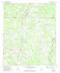
1971 Map of Haralson
USGS Topo · Published 1984About this map
Haralson and Alvaton anchor this West Georgia landscape along the Seaboard Coast Line railroad, which cuts a sharp north-south path through the rolling hills of Coweta and Meriwether counties. The rural character of the early 1970s is evident in the dense network of country churches and community landmarks, such as Mt Carmel Ch and Piney Grove Ch, and local school sites like McCrary Sch.
Find a feature on this map
38 named features on this map. Tap any name to fly to it.
Don’t see what you’re looking for? This feature index may not catch every label — zoom into the map to look around manually.
Map Details
Editions of this 1971 Haralson Map
2 editions found
Other maps of this area

1953 · Atlanta
USGS Topo · 1:250,000

1957 · Atlanta
USGS Topo · 1:250,000

1958 · Atlanta
USGS Topo · 1:250,000

1965 · Senoia
USGS Topo · 1:24,000

1965 · Brooks
USGS Topo · 1:24,000

1965 · Sharpsburg
USGS Topo · 1:24,000
1971 · Luthersville
USGS Topo · 1:24,000
1971 · Greenville
USGS Topo · 1:24,000

1971 · Hollonville
USGS Topo · 1:24,000
1971 · Haralson
USGS Topo · 1:24,000