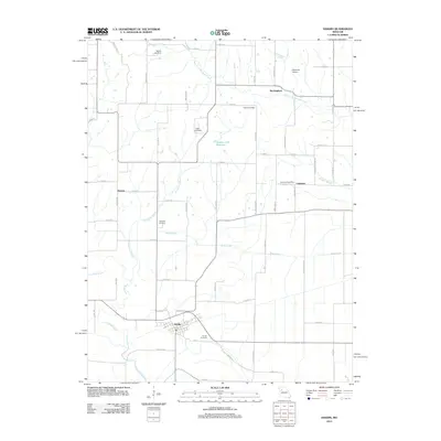
2012 Map of Hardin
USGS Topo · Published 2012About this map
Hardin anchors the southern portion of this Ray County landscape, where the town grid meets the winding course of the Crooked River. The terrain is defined by a dense network of agricultural roads and waterways, including the West Fork Wakenda Creek and the aptly named Dangerous Branch. Smaller settlements like Rockingham, Morton, and Lakeview serve as local nodes within this rural framework, with the latter still identified by its Lakeview Post Office. Local family and community history is preserved at several sites, most notably Hardin Cemetery, Lavelock Cemetery, and Clarks Cemetery. This early 21st-century survey documents the persistent water management systems of the area, ranging from the Number 170 Reservoir to the Waller Lake Dam and the tidal-like Booker Slough that feeds into the river valley.
Find a feature on this map
62 named features on this map. Tap any name to fly to it.
Don’t see what you’re looking for? This feature index may not catch every label — zoom into the map to look around manually.
Map Details
Editions of this 2012 Hardin Map
This is the sole edition of this map. No revisions or reprints were ever made.
Other maps of this area

1889 · Lexington
USGS Topo · 1:125,000

1949 · Lexington East
USGS Topo · 1:24,000

1949 · Lexington West
USGS Topo · 1:24,000

1950 · Lexington East
USGS Topo · 1:24,000
1950 · Lexington West
USGS Topo · 1:24,000

1950 · Dover
USGS Topo · 1:24,000
1951 · Dover
USGS Topo · 1:24,000

1953 · Moberly
USGS Topo · 1:250,000

1954 · Moberly
USGS Topo · 1:250,000

1957 · Moberly
USGS Topo · 1:250,000