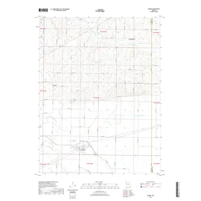
2017 Map of Hardin
USGS Topo · Published 2017About this map
Hardin anchors the southern landscape of this Ray County quadrangle, situated where the terrain transitions toward the fertile bottomlands of the Crooked River. The town's grid is clearly defined, with the Hardin Cem nearby, while the smaller settlement of Morton lies to the northwest along State Highway E. The map reveals an intricate network of rural infrastructure, including the managed water of the Norborne Drainage Ditch and the winding course of the W Fork Wakenda Cr in the northern hills. Local history is reflected in several family and community landmarks, such as Lavelock Cem and Clarks Cem, alongside curiously named features like Dangerous Br and Booker Slough. This modern survey illustrates how agricultural patterns have integrated with the natural drainage systems of the Missouri landscape.
Find a feature on this map
82 named features on this map. Tap any name to fly to it.
Don’t see what you’re looking for? This feature index may not catch every label — zoom into the map to look around manually.
Map Details
Editions of this 2017 Hardin Map
This is the sole edition of this map. No revisions or reprints were ever made.
Other maps of this area

1889 · Lexington
USGS Topo · 1:125,000

1949 · Lexington East
USGS Topo · 1:24,000

1949 · Lexington West
USGS Topo · 1:24,000

1950 · Lexington East
USGS Topo · 1:24,000
1950 · Lexington West
USGS Topo · 1:24,000

1950 · Dover
USGS Topo · 1:24,000
1951 · Dover
USGS Topo · 1:24,000

1953 · Moberly
USGS Topo · 1:250,000

1954 · Moberly
USGS Topo · 1:250,000

1957 · Moberly
USGS Topo · 1:250,000