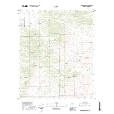
2023 Map of Hardscrabble Mountains
USGS Topo · Published 2023About this map
White Sands Missile Range dominates the central portion of this Sierra County landscape, marking an era of federal restricted land use in the New Mexico desert. The topography is defined by the sharp elevations of the Hardscrabble Mountains and the San Andres Mountains, where water is a precious and scattered resource found at sites like Bear Den Spring, Rock House Spring, and Hardscrabble Spring. Transportation through this arid terrain relies on historic corridors such as Rhodes Pass and Indian Trail Gap, while unpaved routes like WSMR P Route 6 weave between high points including Grandaddy Peak and Skillet Knob. The map reveals a complex network of canyons and draws, such as Shannon Canyon and Brushy Draw, providing a detailed look at the drainage patterns and geological formations that characterize the northern reaches of the missile range.
Find a feature on this map
49 named features on this map. Tap any name to fly to it.
Don’t see what you’re looking for? This feature index may not catch every label — zoom into the map to look around manually.
Map Details
Editions of this 2023 Hardscrabble Mountains Map
This is the sole edition of this map. No revisions or reprints were ever made.
Other maps of this area

1916 · Salinas Peak
USGS Topo · 1:125,000

1948 · Sowell
USGS Topo · 1:62,500

1948 · Malpais Well
USGS Topo · 1:62,500

1948 · Black Top Mountain
USGS Topo · 1:62,500

1948 · Salinas Peak
USGS Topo · 1:62,500

1954 · Tularosa
USGS Topo · 1:250,000

1958 · Tularosa
USGS Topo · 1:250,000

1981 · Big Gyp Mountain
USGS Topo · 1:24,000
1981 · Shannon Canyon
USGS Topo · 1:24,000
1981 · Hardscrabble Mountains
USGS Topo · 1:24,000