1994 Map of Harney Lake
USGS Topo · Published 1994About this map
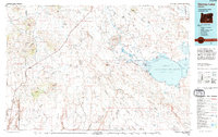
The expansive Malheur National Wildlife Refuge anchors the eastern half of this high-desert landscape, where the waters of Harney Lake and Malheur Lake provide a vital sanctuary. This 1994 edition reveals a vast network of terminal lake basins and seasonal wetlands, including Silver Lake and Stinking Lake, situated between prominent landforms like the Palomino Rim and Coyote Rim. The map documents a sparsely populated ranching country, capturing isolated outposts such as the Frank Schmidt Ranch and Albert Ranch, alongside the settlement of Wagontire at the base of Wagontire Mtn. Significant geological and topographical curiosities are noted, such as the Hole in the Ground near the Alkali Flat, and the distinct elevation of Wrights Point stretching into the Harney Valley.
Find a feature on this map
74 named features on this map. Tap any name to fly to it.
Don’t see what you’re looking for? This feature index may not catch every label — zoom into the map to look around manually.
Map Details
Editions of this 1994 Harney Lake Map
This is the sole edition of this map. No revisions or reprints were ever made.
Other maps of this area

1955 · Crescent
USGS Topo · 1:250,000

1955 · Klamath Falls
USGS Topo · 1:250,000

1955 · Burns
USGS Topo · 1:250,000

1955 · Adel
USGS Topo · 1:250,000

1957 · Adel
USGS Topo · 1:250,000

1957 · Crescent
USGS Topo · 1:250,000

1958 · Crescent
USGS Topo · 1:250,000

1958 · Klamath Falls
USGS Topo · 1:250,000

1958 · Burns
USGS Topo · 1:250,000

1958 · Adel
USGS Topo · 1:250,000