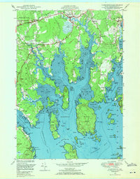
1948 Map of Harrington
USGS Topo · Published 1971About this map
Harrington and West Harrington serve as the primary inland hubs for this coastal Washington County landscape, where the Harrington River and Mill River carve a complex network of coves and points into the shoreline. The settlement pattern reflects a mid-century community tied to the land and sea, marked by numerous local institutions such as the Church in the Wildwood and the Union Ch. Small neighborhood schools, including Coffin Sch and Wards Cove Sch, are scattered throughout the quadrangle, serving families across Marshville and Dorman.
Find a feature on this map
131 named features on this map. Tap any name to fly to it.
Don’t see what you’re looking for? This feature index may not catch every label — zoom into the map to look around manually.
Map Details
Editions of this 1948 Harrington Map
2 editions found
Other maps of this area

1902 · Cherryfield
USGS Topo · 1:62,500

1904 · Cherryfield
USGS Topo · 1:62,500

1904 · Petit Manan
USGS Topo · 1:62,500

1921 · Great Wass Island
USGS Topo · 1:62,500

1921 · Columbia Falls
USGS Topo · 1:62,500

1921 · Columbia Falls
USGS Topo · 1:62,500

1941 · Columbia Falls
USGS Topo · 1:62,500

1942 · Cherryfield
USGS Topo · 1:62,500

1942 · Columbia Falls
USGS Topo · 1:62,500
1948 · Columbia Falls
USGS Topo · 1:24,000