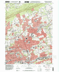
1993 Map of Harrisburg East
USGS Topo · Published 1999About this map
Blue Mountain anchors the northern landscape, its ridgeline separating the residential growth of Lower Paxton from the more rural terrain of Middle Paxton. In the early 1990s, this area east of the state capital shows a dense network of suburban development spreading from established centers like Linglestown and Colonial Park. The infrastructure of the era is clearly defined, with the Conrail rail lines and prominent landmarks like the Harrisburg State Hospital and Harrisburg High Sch marking the transition into the city's eastern neighborhoods.
Find a feature on this map
79 named features on this map. Tap any name to fly to it.
Don’t see what you’re looking for? This feature index may not catch every label — zoom into the map to look around manually.
Map Details
Editions of this 1993 Harrisburg East Map
This is the sole edition of this map. No revisions or reprints were ever made.
Other maps of this area

1892 · Hummelstown
USGS Topo · 1:62,500

1892 · Harrisburg
USGS Topo · 1:62,500

1899 · Harrisburg
USGS Topo · 1:62,500

1906 · New Cumberland
USGS Topo · 1:62,500

1908 · Middletown
USGS Topo · 1:62,500

1924 · Hummelstown
USGS Topo · 1:62,500

1924 · Harrisburg
USGS Topo · 1:62,500

1943 · New Cumberland
USGS Topo · 1:62,500

1943 · Middletown
USGS Topo · 1:62,500

1943 · Harrisburg
USGS Topo · 1:62,500
Featured Places
- Harrisburg, PA
- Colonial Park, Lower Paxton Township
- Progress, Susquehanna Township
- Linglestown, Lower Paxton Township
- Rutherford, Swatara Township