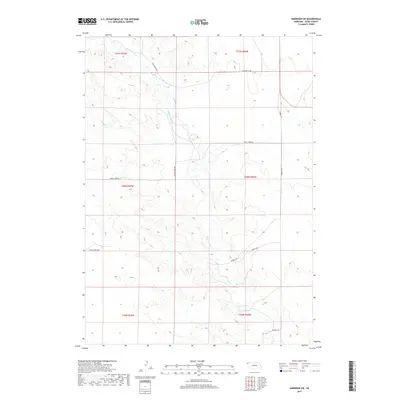
2017 Map of Harrison SW
USGS Topo · Published 2017About this map
The Niobrara River meanders across this rural corner of Sioux County, defining the drainage patterns and historical development of the Bowen Precinct area. This 2017 survey illustrates a sparsely populated landscape dominated by township lines and cattle-country infrastructure. The winding course of the river is complemented by the Lakotah Canal, which runs parallel to the waterway in the northern sections, signaling the importance of irrigation in this high-plains environment. Long stretches of county roads, such as Morrill Rd and Circle Butte Rd, follow the section lines, providing a clear view of the Public Land Survey System that partitioned the Nebraska panhandle. This map serves as a modern record of land use and water management in a region where the terrain and hydrology dictate the layout of every ranch road and boundary.
Find a feature on this map
11 named features on this map. Tap any name to fly to it.
Don’t see what you’re looking for? This feature index may not catch every label — zoom into the map to look around manually.
Map Details
Editions of this 2017 Harrison SW Map
This is the sole edition of this map. No revisions or reprints were ever made.
Other maps of this area

1896 · Patrick
USGS Topo · 1:125,000

1899 · Whistle Creek
USGS Topo · 1:125,000

1954 · Torrington
USGS Topo · 1:250,000

1955 · Alliance
USGS Topo · 1:250,000

1957 · Alliance
USGS Topo · 1:250,000

1958 · Torrington
USGS Topo · 1:250,000

1958 · Alliance
USGS Topo · 1:250,000

1977 · Van Tassell
USGS Topo · 1:24,000

1977 · Van Tassell SE
USGS Topo · 1:24,000
1978 · Torrington
USGS Topo · 1:100,000