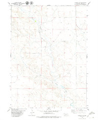
1979 Map of Harrison SW
USGS Topo · Published 1979About this map
The Niobrara River carves a winding path across this portion of Sioux County, defining the drainage patterns and physical character of the High Plains landscape. The river's influence is evident in the presence of the Lakatoh Ditch, an irrigation feature that speaks to the agricultural management of the region's semi-arid environment. Compiled from aerial photography taken in 1973 and field-checked by the U.S. Geological Survey in 1974, this map provides a precise record of water resources and ranch-land infrastructure during the late twentieth century. Beyond the main river channel, the terrain is marked by isolated landmarks such as a specific Drill Hole and several rural wells, reflecting the local reliance on groundwater and the ongoing exploration of the area's geological potential.
Find a feature on this map
4 named features on this map. Tap any name to fly to it.
Don’t see what you’re looking for? This feature index may not catch every label — zoom into the map to look around manually.
Map Details
Editions of this 1979 Harrison SW Map
This is the sole edition of this map. No revisions or reprints were ever made.
Other maps of this area

1896 · Patrick
USGS Topo · 1:125,000

1899 · Whistle Creek
USGS Topo · 1:125,000

1954 · Torrington
USGS Topo · 1:250,000

1955 · Alliance
USGS Topo · 1:250,000

1957 · Alliance
USGS Topo · 1:250,000

1958 · Torrington
USGS Topo · 1:250,000

1958 · Alliance
USGS Topo · 1:250,000

1977 · Van Tassell
USGS Topo · 1:24,000

1977 · Van Tassell SE
USGS Topo · 1:24,000
1978 · Torrington
USGS Topo · 1:100,000