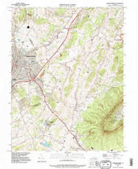
1989 Map of Harrisonburg
USGS Topo · Published 1995About this map
The sprawling campus of James Madison University and the urban center of Harrisonburg dominate the western portion of this Shenandoah Valley landscape. In the late 20th century, the city's expansion is evident through its network of residential streets and institutional grounds, including Woodbine Cem and Hebrew Cem. East of the city, the terrain transitions into the steep, forested slopes of Massanutten Mountain, reaching a summit at Massanutten Peak.
Find a feature on this map
33 named features on this map. Tap any name to fly to it.
Don’t see what you’re looking for? This feature index may not catch every label — zoom into the map to look around manually.
Map Details
Editions of this 1989 Harrisonburg Map
This is the sole edition of this map. No revisions or reprints were ever made.
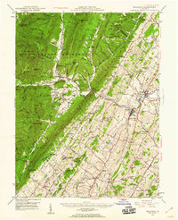
Other maps of this area

1892 · Woodstock
USGS Topo · 1:125,000

1892 · Harrisonburg
USGS Topo · 1:125,000

1937 · Elkton
USGS Topo · 1:62,500

1941 · Harrisonburg
USGS Topo · 1:62,500

1942 · Mt Jackson
USGS Topo · 1:62,500

1943 · Harrisonburg
USGS Topo · 1:62,500

1946 · Mt Jackson
USGS Topo · 1:62,500

1947 · Mt Jackson
USGS Topo · 1:62,500
1947 · Broadway
USGS Topo · 1:62,500

1949 · Charlottesville
USGS Topo · 1:250,000