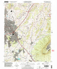
2002 Map of Harrisonburg
USGS Topo · Published 2004About this map
Harrisonburg anchors this Shenandoah Valley landscape at the dawn of the 21st century, showing the city's relationship with the surrounding Rockingham County topography. The survey details the urban expansion of James Madison University and local landmarks like the Ashby Monument and Massanutten Caverns. Significant local history is preserved in the locations of Woodbine Cem, Hebrew Cem, and the Ralph Sampson Park Cem. To the east, the dramatic rise of Massanutten Mountain and Massanutten Peak overlooks established settlements such as Keezletown and Penn Laird. The area is defined by its water and transport networks, from the Norfolk Southern railroad line and major highway interchanges to the course of Cub Run and the recreational waters of Lake Shenandoah.
Find a feature on this map
37 named features on this map. Tap any name to fly to it.
Don’t see what you’re looking for? This feature index may not catch every label — zoom into the map to look around manually.
Map Details
Editions of this 2002 Harrisonburg Map
This is the sole edition of this map. No revisions or reprints were ever made.
Other maps of this area

1892 · Woodstock
USGS Topo · 1:125,000

1892 · Harrisonburg
USGS Topo · 1:125,000

1937 · Elkton
USGS Topo · 1:62,500

1941 · Harrisonburg
USGS Topo · 1:62,500

1942 · Mt Jackson
USGS Topo · 1:62,500

1943 · Harrisonburg
USGS Topo · 1:62,500

1946 · Mt Jackson
USGS Topo · 1:62,500

1947 · Mt Jackson
USGS Topo · 1:62,500
1947 · Broadway
USGS Topo · 1:62,500

1949 · Charlottesville
USGS Topo · 1:250,000