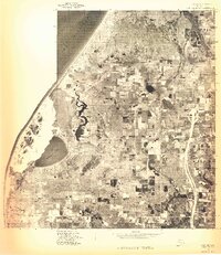
1976 Map of Hart NW
USGS Topo · Published 1976About this map
Lake Michigan dominates the western edge of this 1976 orthophotoquad, where the shifting sands of Little Point Sable meet the shoreline. This aerial perspective reveals a unique transitional landscape where coastal dunes transition into the agricultural grid of Oceana County. The inland waters of Silver Lake are clearly defined, showing the proximity of these freshwater basins to the Great Lakes coast. Further east, the small settlement of Mears appears as a distinct cluster within the network of farm fields and woodlots, providing a clear look at rural land use and development patterns in the mid-1970s. This photographic survey, captured in May 1976, provides a direct visual record of the shoreline and dunes before later decades of environmental change and local expansion.
Find a feature on this map
4 named features on this map. Tap any name to fly to it.
Don’t see what you’re looking for? This feature index may not catch every label — zoom into the map to look around manually.
Map Details
Editions of this 1976 Hart NW Map
This is the sole edition of this map. No revisions or reprints were ever made.
Other maps of this area

1931 · Hart NW
USGS Topo · 1:31,680

1931 · Hart SE
USGS Topo · 1:31,680

1931 · Hart NE
USGS Topo · 1:31,680

1932 · Ludington SW
USGS Topo · 1:31,680

1932 · Ludington SE
USGS Topo · 1:31,680

1954 · Milwaukee
USGS Topo · 1:250,000

1958 · Milwaukee
USGS Topo · 1:250,000

1959 · Ludington
USGS Topo · 1:62,500

1959 · Hart
USGS Topo · 1:62,500
1976 · Hart SE
USGS Topo · 1:24,000